The Site
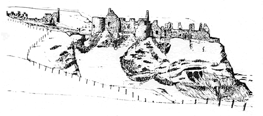
Dunluce is situated on the Antrim coast, 3 miles E. of Portrush, and 2 miles W. of Bushmills. The site was ideally suited for the purposes of medieval defence, ‘an insulated perpendicular rock of one hundred feet high, standing proudly among the boiling waves which foam around and wash its sides, and separated from the mainland by a precipitous chasm of about twenty feet wide, and nearly a hundred feet deep’. The basaltic rock, over two hundred feet long, has been penetrated from its seaward end by wave action leaving a natural harbour, easily accessible in reasonable weather, and capable of concealing a number of galleys, the craft commonly used in medieval times along the Irish coast and among the Scottish Islands.
The History
For more than four centuries the castle occupied a position of strategic importance, between the pastures of Antrim and the sea routes along the coast. Long before the castle was built the great rocky outcrop had been recognized as a place of retreat; on the NE. side of the summit of the rock an underground passage, or souterrain, was cut in the Early Christian period, about a thousand years ago. It was probably used as a refuge. The earliest parts of the castle, apparently dating from the 14th century, are the two E. towers and the S. wall. The castle is, however, curiously absent from surviving records until the early 16th century when it appears in the hands of the ‘brave, hospitable and improvident" family of the MacQuillans. Through marriage and stealth they were displaced by the Macdonnells, a Scottish clan who, in taking advantage of the strife between the native Irish and Queen Elizabeth’s generals, made up for territorial losses to the Campbells in Argyll and Islay by acquisitions in north Antrim. It is from the late 16th century that most of the present remains dale. Virtually impregnable before the introduction of efficient artillery, the castle was badly damaged in 1584 by the English Lord Deputy, Sir John Perrot, reputedly a son of Henry VIII whom he resembled in stature and temper. Arriving at Dunluce with a large force, he besieged and shattered the castle with “a culverin and two shakers of brass’. The Macdonnell fortunes were restored by Sorley Boy Macdonnell, who displayed skill both as military tactician and diplomat, and emerged as governor of Dunluce, with extensive territories which formed the estates of his descendants the Earls of Antrim. Sorley Boy and his son James rebuilt and extended the castle in the late 16th century to withstand the rigours of artillery warfare. And their successors added the more comfortable features of the castle early in the 17th century. Only occasionally occupied after the 1641-2 wars the castle fell into decay. In 1928 the seventh Earl of Antrim transferred the ruins to the Government for preservation as a monument in State Care.

A Tour of the Castle
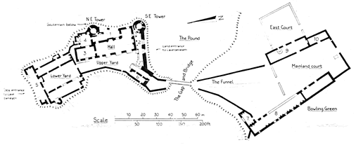
The Mainland Court, through which the visitor approaches the castle, appears to date from the 17th century. It provided extra accommodation and greater protection against surprise attack and artillery fire. As the need for defence declined, so the landward buildings were increasingly used, and the castle neglected. The Duchess of Buckingham, wife of the second Earl of Antrim, particularly disliked the noise of the sea, and when in 1639 a section of the castle fell away, carrying with it several members of the household, she decided to build a new house further inland. One fragment of building near the car park gate may relate to this new house, and the mainland court may have been used as stable-yard and offices; the function of each of the buildings which surround it can only be suggested. The long range to the W. once divided into two storeys of small rooms each with a window and a hearth, probably served as lodgings (8). The cliff room (7) at its N. end, having two hearths was probably divided. The building to the E. may have been a smithy (9), while its neighbour was probably a stable (10).
The thick walls of the Funnel converge on the bridge, the only access to the main castle. The present bridge is sited where originally some kind of drawbridge formed the castle’s first line of defence. This would have been dominated by a gatehouse which appears to have been severely damaged by Perrot’s artillery in 1584. The present Gatehouse (6) dates from the subsequent rebuilding by the Macdonnells and, not surprisingly, is Scottish in ‘its use of circular turrets built out from the upper corners on stepped, or corbelled, courses of moulded stone. By the steps at the inner end of the gatehouse, scratched onto the wall, is a drawing of unknown date of a masted galley.
The South Wall facing the mainland was probably also damaged in the siege. It was made thicker, and two openings were cut through it, possibly to receive the cannon which Sorley Boy took from the Girona, a Spanish Armada galleass, wrecked at nearby Port na Spaniagh in 1588. Behind the S. wall are the lower parts of a row of columns, originally supporting an arcade or vault (see conjectural reconstruction on front page), which formed a loggia (2) open on the N. side. The reason for this covered way with such sophisticated stonework is unknown. With a N. outlook it can hardly have been for climatic enjoyment. Curiously, however, a similar arrangement also of the 16th century may be seen at St. Andrew’s Castle in File. The Dunluce loggia was obscured when the hall was built early in the 17th century.

At the end of the loggia is the circular South East Tower, which is the only substantial part of the original castle to remain unchanged since it was built. Prominent on the landward side it seems to have served as both look-out and flanker, with loopholes covering approaches to the bridge. It was never finished to provide living accommodation. From here can be seen the Pound, a low valley between castle and mainland where animals could easily be confined.
Dominating the Upper Yard is the Hall. the grandest and perhaps latest building on the rock, dating from the early 17th century. Bay windows line the W. front; a moulded string-course divides the two storeys; and a main door to the left is surmounted by three weathered stone heads. The hall was the centre of the castle’s life. The windows must have made the tall interior unusually light. Here before the great heraldic chimney-piece the Earls of Antrim conducted their affairs and made their plans. Here they ate and drank, and entertained with music and dancing. And it was probably here in 1642 that the 2nd Earl was seized by one of his own dinner guests, the Scottish General Monroe, and taken prisoner to Carrickfergus. To help heat the great space of the hall there was a second fireplace in the S. gable. An extension to the SE. probably contained a wide staircase leading to the upper floor, where remains only a single window in the N. gable with its stone mullion and transom intact. The lower building beyond the hall was the buttery (3) used to store provisions for the hall and kitchen. Its upper floor was reached by an outsidi- staircase. Behind the hall in the East Court is the entrance to the souterrain (1), a rock-cut passage about 40 feet long and 3-4 feet high, leading beneath the NE. Tower to a small aperture on the cliff face. Pottery and bones found inside, dating from the Early Christian period, are the earliest evidence for man’s occupation of the rock. The E. court was once larger but rock falls necessitated the building of a new curtain wall; parts of the original wall may be seen attached to the NE. tower and on the cliff below. The North East Tower, built through the souterrain, has a lower chamber, with vaulting still imprinted by the wickerwork centering on which it was built. The upper parts of the tower, reached by a staircase in the thickness of the tower’s cylindrical wall, were partly rebuilt for habitation. To the N. of the NE. Tower is the kitchen (4) with its wide fireplace, stone-built ovens, stone guttering for drainage and cupboard recesses. A passage beyond the kitchen leads to the Lower Yard, which retains its cobbled surface, and was surrounded by service buildings and ‘domestic quarters. The range to the W. included the bakery which has a double bread oven. The E. range provided living quarters with hearths and a latrine built out beyond the E. wall. The N. range is the most damaged, its N. wall having fallen from the clifftop into the rocks about the sea entrance to the cave below. This is one possible site (another by the kitchen has been suggested) of the disastrous collapse of 1639 which caused several deaths and led ultimately to the abandonment of the castle in favour of more comfortable and less hazardous accommodation on the mainland. From the W. window of the N. range the visitor has one of the most famous views of the Antrim coast with the limestone arches of the White Rocks and the Portrush strand beyond.